AIMS
AIMS AIMS-H Long Focus
 Farsightâ„¢ System
 Riegl VQ-1560i
 Riegl VQ-780II
 UltraCam Eagle M3
 Y-1 VTOL UAV
 Aerial Acquisition
 UAV Acquisition
 Satellite Acquisition
 Field Acquisition
 Integrated
 LiDAR
LiDAR Orthophoto
 DEM
DEM DTM/DSM
 3D Mapping
 Topographic
 Infrared
 Feature Extraction
 BIM
BIM Transportation
 Water
Water power
power  Forestry
 Agriculture
 Mines & Quarries
 Heritage Buildings
 About feiyan
 Recognition
 Cases
Cases

search


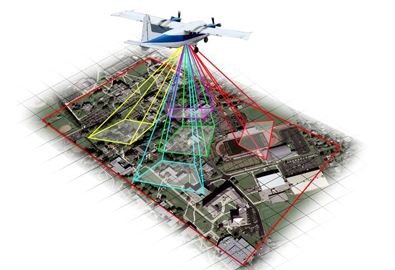
Applications of UAV Orthophotos
Apr 10, 2023
Orthophotos are remote sensing images with orthographic projection properties. The original remote sensing image will be distorted and distorted to varying degrees due to the influence of the sensor's internal state changes, external state and surface conditions during imaging. The geometric processing of remote sensing images not only needs to extract spatial information, but also needs to resample the image grayscale according to the correct geometric relationship to form a new orthophoto.

Although the application field of UAV orthophotos is very broad, there are still situations in which buildings on the images are tilted or blocked between buildings during the aerial photography process. This is mainly because the aerial image adopts the central projection method, high-rise buildings will produce oblique building image occlusion, and at the same time there will be occlusion between high-rise buildings, buildings and the ground, which will directly affect the later surveying and mapping work.
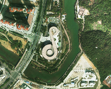
UAV orthophoto is a new type of digital surveying and mapping product, which has a very broad application prospect. Through real images and rich colors to objectively reflect the performance of the ground, it has the characteristics of rich ground information, intuitive ground features, high work efficiency, and short production cycle. In addition, the data of the digital orthophoto map is also more convenient to use. It can not only be used to update the digital line map data and improve the update speed of the topographic map, but also can be directly applied to various geographic information systems of the city as a background map, and can also be superimposed with the line map and text annotation to form an image map. Orthophoto not only enriches the form of the map, but also increases the amount of information of the map. 


-
 Jul 21, 2021
The project of Taizhou Natural Resources and Planning Bureau passed the acceptance
Last month, the project of Taizhou Natural Resources and Planning Bureau executed by Feiyan has been accepted successfully. This project aims to acquire 863 kmآ² of orthophoto in Taizhou with 0.1m ground resolution (1:1000). The project encountered various difficulties including blurred images due to bad weather, air traffic control etc, but the team still finished the task within 2 months. Vertical resolution of the results was 0.07m, which is more than 30% better than the national standard. The governmental assessment committee highly praise the project with “high efficiency executionâ€, and “high quality imagery resultsâ€.آ More > -
May 12, 2023
What Is Oblique Photography?
Oblique photography technology is a high-tech developed in the field of international surveying, mapping and remote sensing in recent years. More >