AIMS
AIMS AIMS-H Long Focus
 Farsightâą System
 Riegl VQ-1560i
 Riegl VQ-780II
 UltraCam Eagle M3
 Y-1 VTOL UAV
 Aerial Acquisition
 UAV Acquisition
 Satellite Acquisition
 Field Acquisition
 Integrated
 LiDAR
LiDAR Orthophoto
 DEM
DEM DTM/DSM
 3D Mapping
 Topographic
 Infrared
 Feature Extraction
 BIM
BIM Transportation
 Water
Water power
power  Forestry
 Agriculture
 Mines & Quarries
 Heritage Buildings
 About feiyan
 Recognition
 Cases
Cases

search


Redundant Data Removal Method Between Laser Radar Lanes
Apr 20, 2023
When airborne lidar technology acquires point cloud data, due to the limitation of scanning field of view and altitude, it usually needs to fly multiple routes. A certain degree of lateral overlap needs to be set between these routes to ensure that data collection can cover the entire survey area. Since these side overlapping areas will be covered by the point clouds of the two strips, the density is greater than other areas, so data redundancy will be formed in the overlapping areas, which will lead to non-uniform spatial distribution of laser point clouds, and LiDAR data in the strips The accuracy of point cloud data with edges is poor, and removing redundant data is an important step in the later stage of LiDAR data processing and product production.

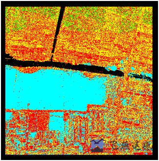
Figure1: Point Cloud Preprocessing Data Before Eliminating Redundancy
Generally, the measurement error of the laser point is proportional to the laser scanning angle. The closer to the edge of the strip, the greater the error of the point cloud. For the redundant part of the overlapping area of the laser radar strip, use the cut-overlap function of the Terrasolid software, according to the complete route Information, based on the theoretical basis that the point cloud accuracy decreases with the increase of the scan angle, so as to remove the point cloud with a larger flight scan angle in the overlapping area of the flight belt, and retain the points with higher quality close to the center of the flight belt, which can effectively eliminate the Data redundancy between bands.

Figure2: After Point Cloud Preprocessing Data Eliminates Redundancy


-
 Mar 18, 2022
Feiyan Invested 20 Million For Airborne LiDAR Measurement
Feiyan invested 20 million to introduce airborne LiDAR measurement, which once again laid the foundation for the hardware strength of feiyan in the industry. More > -
Mar 22, 2022
What is LiDAR point cloud data?
LiDAR (laser detection and ranging) is an optical Remote sensing technology which mainly USES the laser as the emitting light source and adopts the active Remote sensing equipment of photoelectric detection technology. Primarily used in airborne laser mapping applications, it is increasingly becoming a cost-effective alternative to traditional measurement techniques such as photogrammetry. More > -
Mar 22, 2022
The Riegl Vq-1560i Airborne Laser Lidar Lived up to Expectations
The ninth China surveying and mapping geographic information technology equipment expo has been successfully concluded. More > -
Mar 22, 2022
Lidar Forest Survey, Incomparable Advantages
In recent years, LiDAR forest survey has attracted more and more people's attention. However, the hotter this new technology is, the more it needs to be understood from all aspects calmly. More > -
Mar 22, 2022
Lidar Is a Key Technology Involved in Terrain Mapping
This question cannot be asked like that. Aerial photography must be sunny, but the altitude angle of the sun must be considered. More > -
Mar 22, 2022
LiDAR and Hyperspectral Remote Sensing Data Fusion Realize Complementary Advantages
With the continuous development and progress of earth observation technology, and the continuous diversification of means for obtaining spatial information, the use of a single means of spatial data resources has been difficult to meet people's information needs. Lidar and hyperspectral Remote sensing, as two common Remote sensing methods, have different characteristics: Lidar can quickly, efficiently and accurately obtain three-dimensional spatial data of features, and hyperspectral images can well characterize the spectral information of features , Reflecting the characteristics of its features, materials, texture, etc. The fusion of these two kinds of data can achieve complementary advantages, maximize their respective characteristics, and achieve more accurate intelligent detection and identification of objects and higher-precision classification and extraction, which are widely used in forestry ecology, precision agriculture, environment Monitoring and other fields. More > -
Mar 22, 2022
What Are the Requirements for the Airborne Lidar Camera for the Acquisition of Lidar Point Cloud Data
In the effective altitude range, to ensure the lowest point cloud density, the laser radar maximum laser emission frequency To be higher. More > -
Mar 22, 2022
The Basics of LiDAR
LiDAR is an active Remote sensing system. An active system means that the system itself generates energy - in this case, light - to measure things on the ground. In a LiDAR system, light is emitted from a rapidly firing laser. You can imagine light quickly strobing from a laser light source. This light travels to the ground and reflects off of things like buildings and tree branches. The reflected light energy then returns to the LiDAR sensor where it is recorded. More > -
Mar 22, 2022
What Are the Different Uses of LiDAR Processing?
LiDAR (Light Detection and Ranging) technology and processing is used in a wide range of research and practical applications. With its ability to measure dimensions, distances, textures, and many other aspects of targeted subjects, LiDAR processing has become an increasingly important tool in geology, geography, surveying, agriculture, and forestry. Atmospheric sciences, archaeology, seismology, and geomatics also depend on data gathered using LIDAR processing for research, while physics and astronomy benefit from LiDAR's ability to create highly precise maps. More >