 AIMS
AIMS AIMS-H Long Focus
 Farsightв„ў System
 Riegl VQ-1560i
 Riegl VQ-780II
 UltraCam Eagle M3
 Y-1 VTOL UAV
 Aerial Acquisition
 UAV Acquisition
 Satellite Acquisition
 Field Acquisition
 Integrated
 LiDAR
LiDAR Orthophoto
 DEM
DEM DTM/DSM
 3D Mapping
 Topographic
 Infrared
 Feature Extraction
 BIM
BIM Transportation
 Water
Water power
power  Forestry
 Agriculture
 Mines & Quarries
 Heritage Buildings
 About feiyan
 Recognition
 Cases
Cases

search


Solution

Geotechnical Monitoring & Resource Management
Feiyan enhances site safety and resource governance through continuous geotechnical monitoring. Data from the Y-1 UAV System and satellite sources is fused in our Swift4D Platform to monitor critical risks like slope stability and subsidence. This information feeds a centralized Mineral Resource Management (MRM) system, providing a single source of truth for reserve tracking and hazard mitigation, protecting both assets and personnel.
Our Differentiated Solution Framework
Built on the Swift4D Platform, our framework integrates multi-source sensing, risk analysis, and collaborative management:
Air-Space-Ground Monitoring: Y-1 UAVs with LiDAR and optical sensors conduct high-frequency surveys; satellite InSAR data provides wide-area deformation context. Fusion enables point-area combined monitoring.
Swift4D Deformation Analysis & Alerting: Automated processing of multi-temporal point clouds and imagery generates slope displacement fields and subsidence contour maps, supporting millimeter-level detection and automated threshold alerts.
SwiftAI Hazard Identification: Deep learning automatically identifies cracks, rockfalls, ponding, and other dangerous features, enabling rapid annotation and work order generation.
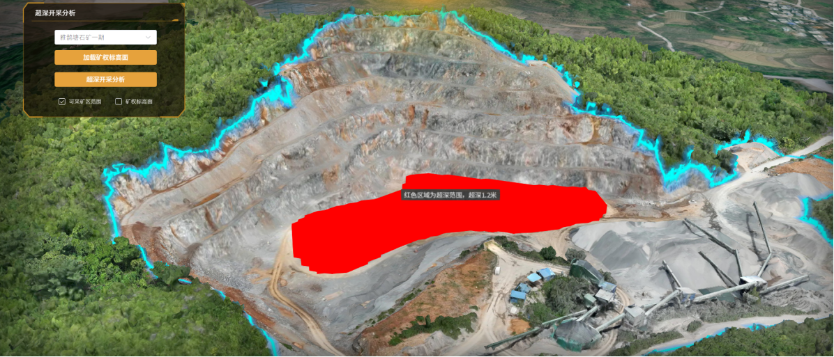
MRM System Integration: Links monitoring data with resource reserve models for integrated management of extraction progress, waste dump stability, and resource consumption.

Application Scenarios & Client Value
Application Scenarios
Open-pit slope stability and dump settlement monitoring


Before the landslide After the landslide
Tailings dam deformation and seepage zone identification
Surface collapse risk assessment from underground mining
Dynamic resource reserve tracking and consumption auditing
Client Value
Controlled Safety Risks: Millimeter-level deformation alerts enable early intervention against landslides and subsidence.

Single Source of Truth: MRM system unifies asset and risk data, eliminating information silos.
Lower Compliance Costs: Automated monitoring replaces manual patrols, reducing labor and regulatory overhead.

Optimized Resource Use: Deformation data linked with reserves improves extraction sequencing and waste disposal.


