AIMS
AIMS AIMS-H Long Focus
 Farsightā¢ System
 Riegl VQ-1560i
 Riegl VQ-780II
 UltraCam Eagle M3
 Y-1 VTOL UAV
 Aerial Acquisition
 UAV Acquisition
 Satellite Acquisition
 Field Acquisition
 Integrated
 LiDAR
LiDAR Orthophoto
 DEM
DEM DTM/DSM
 3D Mapping
 Topographic
 Infrared
 Feature Extraction
 BIM
BIM Transportation
 Water
Water power
power  Forestry
 Agriculture
 Mines & Quarries
 Heritage Buildings
 About feiyan
 Recognition
 Cases
Cases

search


Cases

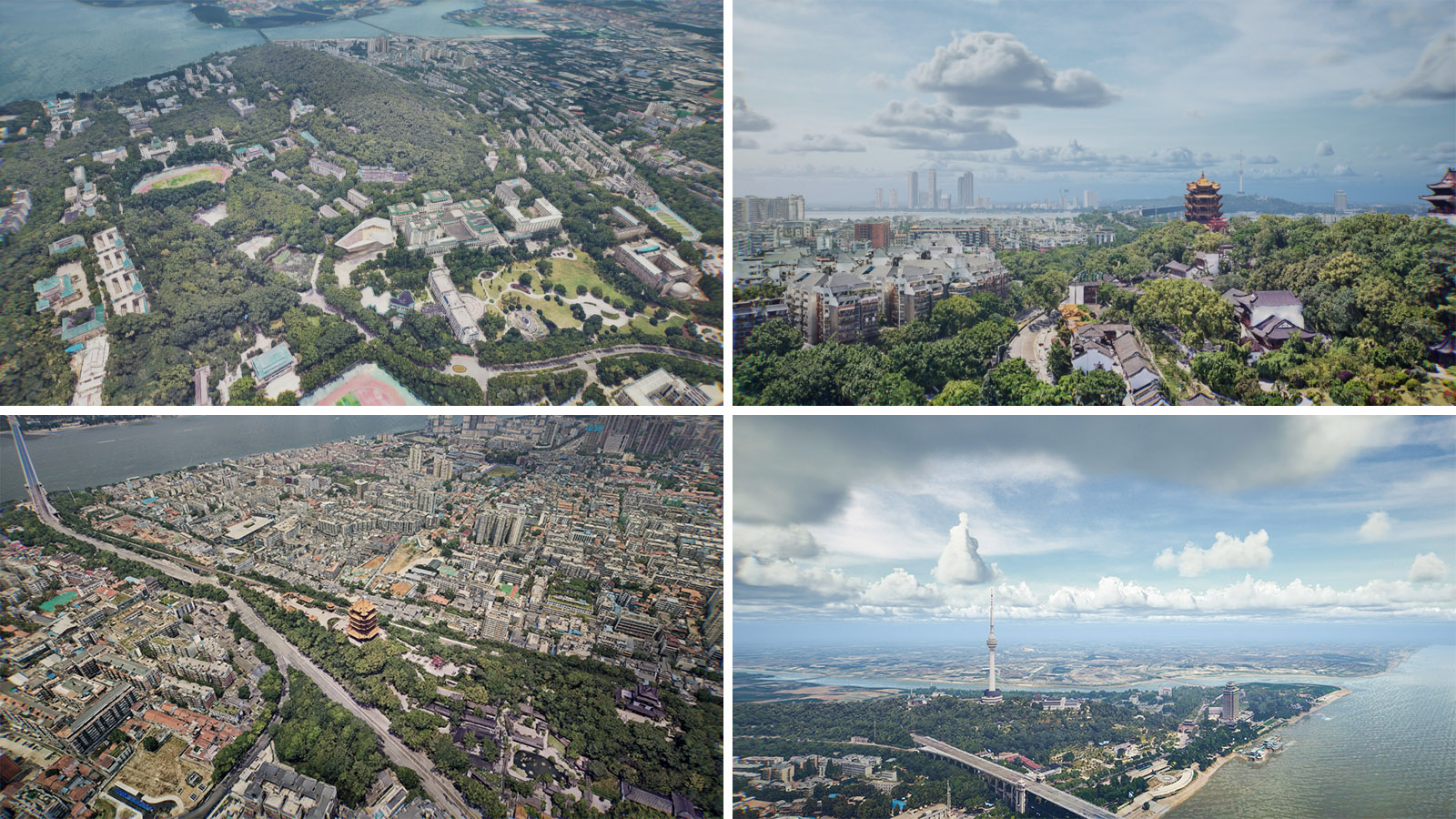
Wuhan basic surveying and mapping project and real scene 3D production
framework level real 3D model, digital elevation model (DEM) and digital surface model (DSM) have been completed for real scene 3D surveying and mapping for 3D Wuhan.
Feiyan Remote Sensing undertook the new basic mapping project of Wuhan, and carried out oblique aerial photography of about 627km2 in the central city with a resolution better than 0.03m.

The framework level real 3D model, digital elevation model (DEM) and digital surface model (DSM) have been completed, which provides 3D basic geographic data support that can be visually measured for urban simulation experiment, territorial space control, construction project approval, emergency response and disposal, and promotes the construction of "real 3D Wuhan".
Application of Real Scene 3D Surveying & Mapping
Architecture and Construction: Real Scene 3D Surveying and Mapping can be used to create accurate as-built models of existing structures, which can help architects and engineers in the design and renovation process. It can also be used to monitor construction progress and identify any discrepancies.
Archaeology and Cultural Heritage: This technology can be used to create detailed 3D models of archaeological sites and cultural heritage structures, which can aid in conservation efforts and historical documentation.
Urban Planning: Real Scene 3D Surveying and Mapping can provide accurate and up-to-date 3D models of cities and towns, which can help urban planners in analyzing the impact of new developments and infrastructure projects.
Film and Video Game Industry: This technology can be used to create realistic and detailed 3D environments for films, TV shows, and video games.
Mining and Exploration: Real Scene 3D Surveying and Mapping can be used to create 3D models of mines and exploration sites, which can help in the planning and optimization of mining operations.
Forensic Investigations: This technology can be used in forensic investigations to create 3D models of crime scenes and accidents, which can aid in the investigation process and provide valuable evidence.
If you need Real Scene 3D Surveying & Mapping for your application, please feel free to contact us to get more useful and professional guidance from us at any time.


-
 May 10, 2021
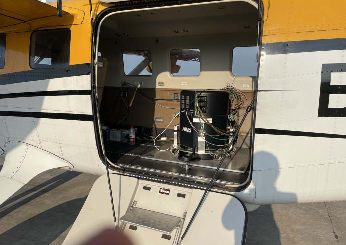
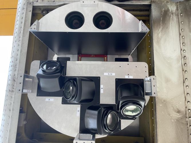
First flight of AIMS
Recently, AIMS,which is theĀ aviation integrated multi-sensor aerial camera,independently developed byĀ Feiyan Aerial Remote SensingĀ Technology Co. , Ltd.Ā has beenĀ successfully carried out the preliminary flight . Nowadays,AIMSĀ is the only oneĀ equipment that has integrated Orthophoto true-color camera, laser radar camera, Tilt Camera, multi-spectral camera, hyperspectral camera, synthetic aperture radar camera and other common aerial sensorsĀ in China.Ā It can acquire multiple data one-time. More > -
Jul 18, 2022
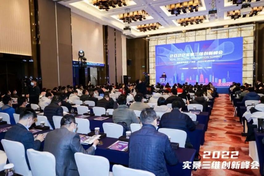
AIMS - Aerial Remote Sensing Solution
The 2022 Real 3D Innovation Summit was successfully held in Guangzhou on January 12. It is guided by the Guangdong Society of Geodesy, hosted by Taibo.com, and co-organized by Feiyan Remote Sensing. It attracted more than 300 experts and industry representatives to attend. More > -
Mar 23, 2022
AIMS Preliminary Flight
Recently, AIMS, which is the aviation integrated multi-sensor aerial camera, independently developed by Feiyan Aerial Remote sensing Technology Co. , Ltd. has been successfully carried out the preliminary flight. More > -
Dec 13, 2025
AIMS Multi-Modal Aerial Survey System Supports 3D Reality Modeling in Wuhan
Wuhan, acclaimed as China's āCapital of Remote Sensing,ā is situated at the confluence of the Yangtze and Han Rivers. The city is home to the historic poetry of the Yellow Crane Tower and the serene beauty of East Lake, while also pulsating with the momentum of modern technology. More >