 AIMS
AIMS AIMS-H Long Focus
 Farsightв„ў System
 Riegl VQ-1560i
 Riegl VQ-780II
 UltraCam Eagle M3
 Y-1 VTOL UAV
 Aerial Acquisition
 UAV Acquisition
 Satellite Acquisition
 Field Acquisition
 Integrated
 LiDAR
LiDAR Orthophoto
 DEM
DEM DTM/DSM
 3D Mapping
 Topographic
 Infrared
 Feature Extraction
 BIM
BIM Transportation
 Water
Water power
power  Forestry
 Agriculture
 Mines & Quarries
 Heritage Buildings
 About feiyan
 Recognition
 Cases
Cases

search


Solution

Comprehensive Flood Inundation Mapping & Damage Analytics
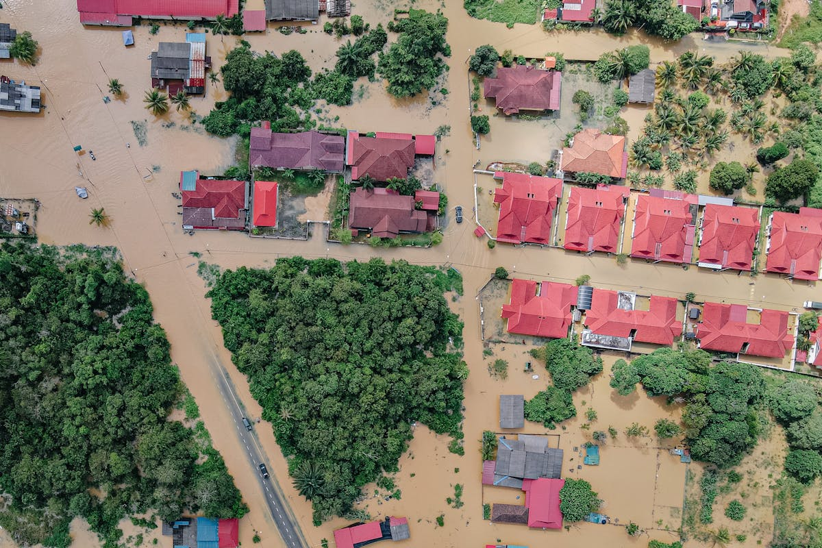
Feiyan Aerial Remote Sensing Tech Co., Ltd. leverages its self-developed Swift4D spatiotemporal big data platform, integrated with UAV surveying, 3D real-scene modeling, and AI analytics, to deliver an end-to-end Flood Inundation Mapping & Damage Assessment Solution. This solution enables rapid response, high-precision modeling, intelligent detection, and multi-dimensional analysis, suitable for government emergency management, insurance claims, infrastructure safety assessment, and moreвҖ”facilitating refined disaster control and data-driven decision-making.
Our Differentiated Solution Framework
Our framework is centered on the Swift4D Platform, enabling an integrated вҖңAir-Space-Ground-CloudвҖқ data collection and analytics system:

1. Rapid Data Acquisition: Using VTOL fixed-wing, multi-rotor, and tethered UAVs for all-weather, high-frequency collection of imagery, LiDAR point clouds, and video over flood-affected areas.
2. Real-Time 3D Modeling: Swift4D supports 5-minute generation of 1 kmВІ 3D models with 10cm ground resolution, enabling accurate measurement of inundation extent, water depth, and volume.
3. AI-Powered Detection & Change Analysis: Through multi-temporal image comparison and deep learning algorithms, we automatically identify flooded areas, damaged structures, road disruptions, crop loss, and generate damage assessment reports and work orders.
4. Multi-Source Data Fusion & Visualization: Integrating satellite remote sensing, IoT sensors, and operational data for a вҖңsingle-map view, single-screen commandвҖқ experience, supporting disaster simulation, emergency plan matching, and resource allocation.
Application Scenarios & Client Value
Core Application Scenarios
1. Flood Emergency Response: For sudden flood disasters, it quickly completes data collection and real-scene 3D modeling in disaster areas, generates real-time flood inundation mapping, accurately locates core inundated areas and trapped points, providing real-time data support for emergency rescue scheduling and mass relocation.

2. Disaster Assessment & Verification: Realize accurate quantification of affected areas and damaged assets through AI intelligent analysis, providing objective and traceable scientific basis for disaster assessment and post-disaster claims of government departments and insurance institutions.
3. Post-disaster Reconstruction & Flood Control Planning: Deduce the evolution law of flood inundation through comparative analysis of multi-phase flood disaster data, providing data support for the layout of post-disaster infrastructure reconstruction, flood control project planning and optimization of basin flood control systems.
Core Client Value
1. Extreme Efficiency: The minute-level real-scene 3D modeling capability of Swift4D upgrades the efficiency of traditional flood survey and mapping from hours to minutes, greatly shortening the emergency response time.
2. Precision & Reliability: 10CM ground resolution real-scene 3D modeling plus AI intelligent recognition achieves centimeter-level precision in inundation mapping and damage analysis, avoiding subjective errors of manual survey.
3. All-round Coverage: The air-space-ground integrated collection system can cover complex terrains such as mountains, rivers, lakes and urban areas, solving the blind spot problem of traditional monitoring.
4. Scientific Decision-making: The trend deduction and plan matching capability of digital twin realizes the transformation from "experience-based decision-making" to "data-driven decision-making", improving the scientific level of flood control and post-disaster management.
5. Flexible Adaptation: Swift4D features high reusability and rapid scenario construction, which can quickly customize functional modules according to the flood control needs of different basins and regions, reducing application costs.


