 AIMS
AIMS AIMS-H Long Focus
 Farsightв„ў System
 Riegl VQ-1560i
 Riegl VQ-780II
 UltraCam Eagle M3
 Y-1 VTOL UAV
 Aerial Acquisition
 UAV Acquisition
 Satellite Acquisition
 Field Acquisition
 Integrated
 LiDAR
LiDAR Orthophoto
 DEM
DEM DTM/DSM
 3D Mapping
 Topographic
 Infrared
 Feature Extraction
 BIM
BIM Transportation
 Water
Water power
power  Forestry
 Agriculture
 Mines & Quarries
 Heritage Buildings
 About feiyan
 Recognition
 Cases
Cases

search


Solution

Proactive Harmful Algal Bloom (HAB) Monitoring & Early Warning
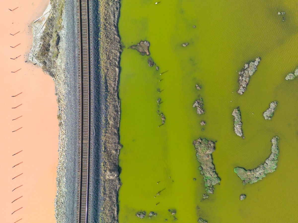
Harmful Algal Blooms (HABs) pose a global challenge to drinking water safety, ecosystem health, and water-dependent economies. Traditional monitoring methods, reliant on manual patrols and fixed stations, suffer from delayed response, limited coverage, and high costs, failing to meet the goal of proactive management through вҖңearly detection, early warning, and early action.вҖқ
Building upon a mature low-altitude remote sensing framework for aquatic ecology, we introduce the Proactive Harmful Algal Bloom (HAB) Intelligent Monitoring and Early Warning Solution. This solution deeply integrates the Y-1 unmanned autonomous drone-in-a-box network, high-resolution multispectral remote sensing, and SwiftAI water quality inversion models, all orchestrated through the Swift4D integrated platform. It establishes a persistent, air-ground integrated monitoring capability, driving the transformation of water body management from passive response to a data-driven, intelligently-alert, and precise governance model.
Our Differentiated Solution Framework
Our framework is a complete technological closed loop integrating automated sensing, intelligent analytics, and decision management.
1. Fully Autonomous Wide-Area Low-Altitude Sensing Network
The Y-1 Low-Altitude Unmanned System forms the scalable, automated backbone of our monitoring network. A single station, with a 50 km operational radius and single-mission coverage exceeding 7,000 kmВІ, enables high-frequency, all-weather data acquisition through 5-minute rapid automatic battery swapping and 7x24 unmanned operation. This overcomes the bottlenecks of traditional satellite remote sensing (long revisit cycles, cloud obstruction) and inefficient manual patrols.
2. SwiftAI-Powered Precision Identification & Inversion Engine
At the core of the solution lies the SwiftAI Intelligence Center. It first employs computer vision to automatically and accurately extract water boundaries from imagery. Subsequently, utilizing validated multispectral remote sensing inversion algorithms, it performs quantitative analysis on the extracted water bodies, accurately calculating key water quality parameters such as Chlorophyll-a (Chl-a), Total Suspended Solids (TSS), and the Trophic Level Index (TLI). Finally, through trained deep learning models, it intelligently identifies the spatial distribution, density, and dynamic trends of algal blooms, achieving the leap from data to actionable insight.
3. Swift4D Integrated Intelligent Management & Decision Platform
The Swift4D Platform serves as the unified "command center," integrating full-chain functionalities including mission planning, data management, AI analytics, and visualization. The platform not only presents a "Unified Water Monitoring Dashboard" for an intuitive overview but also features an embedded intelligent early-warning engine. This engine automatically triggers multi-level alerts based on SwiftAI's inversion results and identification conclusions. It further links with the task management system to achieve a closed-loop digital workflow from anomaly detection and work order dispatch to field verification and feedback, significantly enhancing operational and management efficiency.
Application Scenarios & Client Value
Application Scenario | Core Pain Points | Our Solution | Core Value Delivered to Client |
Routine Patrol & Baseline Survey | Manual patrols are inefficient and costly, making it difficult to promptly understand baseline conditions and subtle changes across large water bodies. | The Y-1 system executes scheduled, automated wide-area patrols, coordinated via the Swift4D platform and processed automatically by SwiftAI to rapidly generate water quality parameter distribution maps. | Significantly improves patrol efficiency and coverage while reducing labor costs. Establishes a precise, visual spatiotemporal water quality baseline database for long-term trend analysis and compliance reporting. |
Early Warning for HABs | Response is often reactive, triggered only after blooms are visibly apparent or publicly reported, missing the optimal intervention window and leading to high disposal costs and potential public crises. | SwiftAI models analyze high-frequency monitoring data to issue warnings days in advance upon detecting abnormal Chlorophyll-a concentrations or specific spatial patterns, with alerts pushed via the Swift4D platform. | Transforms passive response into proactive prevention, minimizing ecological damage and treatment costs. Safeguards water supply safety and public health, upholding the credibility of managing authorities and social stability. |
Outfall & Surface Anomaly Monitoring | Outfalls are often concealed and widespread, making illicit discharges hard to detect promptly; surface debris and oil slicks affect aesthetics and water quality. | The Y-1 system, equipped with visible-light and thermal infrared payloads, conducts routine patrols. SwiftAI algorithms automatically identify events like abnormal discharges and surface floating objects, providing real-time location on the Swift4D map. | Enables rapid discovery and precise location of pollution sources, enhancing environmental enforcement efficiency. Improves precision management of water surface conditions, contributing to aquatic ecological improvement. |
Emergency Monitoring & Response Assessment | Lack of capability to quickly obtain a comprehensive situational overview during sudden water pollution or severe HAB events, hindering decision-making speed and effectiveness evaluation. | Initiating emergency mode via the Swift4D platform rapidly dispatches the nearest Y-1 drone to the site, providing real-time HD video and imagery to quickly delineate the affected area. | Greatly accelerates emergency response speed and decision-making. Provides objective, visual before-and-after evidence for treatment effectiveness, supporting performance evaluation. |
Pollution Source Tracing & Causation Analysis | Difficulty in quickly clarifying pollutant dispersion pathways and potential sources, leading to less targeted treatment measures. | Correlates the spatial distribution of pollution plumes derived from SwiftAI inversion with watershed thematic data (industry, agriculture, pipelines) within the Swift4D platform for spatial association and source tracing analysis. | Drives governance models from end-of-pipe treatment towards source control. Provides critical data insights and decision support for watershed precision management and targeted regulation. |


