 AIMS
AIMS AIMS-H Long Focus
 Farsightв„ў System
 Riegl VQ-1560i
 Riegl VQ-780II
 UltraCam Eagle M3
 Y-1 VTOL UAV
 Aerial Acquisition
 UAV Acquisition
 Satellite Acquisition
 Field Acquisition
 Integrated
 LiDAR
LiDAR Orthophoto
 DEM
DEM DTM/DSM
 3D Mapping
 Topographic
 Infrared
 Feature Extraction
 BIM
BIM Transportation
 Water
Water power
power  Forestry
 Agriculture
 Mines & Quarries
 Heritage Buildings
 About feiyan
 Recognition
 Cases
Cases

search


Solution

Crop Type Classification & Mapping
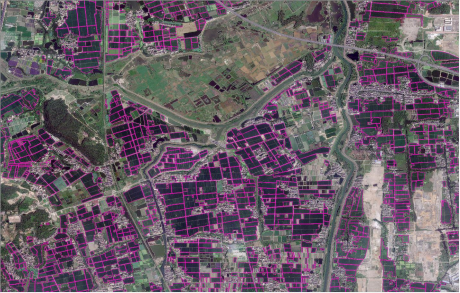
Feiyan delivers crop classification and acreage mapping using the Swift4D Platform and SwiftAI engine, analyzing spectral data from satellites and the AIMS system. By capturing unique spectral responses across key phenological stages, we enable precise identification to support subsidy compliance, supply chain traceability, and land-use auditing.
Our Differentiated Solution Framework
Built on Swift4D, the framework integrates data acquisition, spectral intelligence, and mapping:
Multi-Source Acquisition: AIMS captures large-format imagery, hyperspectral, and LiDAR in one flight; combined with Y-1 UAVs and satellite data for full coverage.
Spectral Intelligence: Analyzes phenological spectral/textural signatures to distinguish wheat, corn, rice, and other major crops.
SwiftAI Classification: Automates crop typing and acreage extraction, generating distribution polygons and statistics with field-level accuracy validation.
Multi-Temporal Comparison: Tracks rotation and land-use changes for compliance and end-to-end supply chain traceability.

Application Scenarios & Client Value
Application Scenarios
Acreage statistics and subsidy compliance (e.g., CAP)

Supply chain traceability and origin certification
Land-use change auditing (abandonment, conversion)
Agricultural insurance underwriting and loss assessment


Precision farming (variable-rate fertilization, yield prediction)

Client Value
Objective: AI eliminates subjective bias, enhancing audit credibility.
Efficient: Thousand-kmВІ mapping compressed from months to weeks.
Reusable: Serves statistics, subsidies, insurance, and auditingвҖ”avoiding duplication.
Traceable: Multi-temporal archiving meets regulatory and trade requirements.
Yield-Optimized: Classification outputs empower precision agriculture, guiding input application and harvest forecasting.


