 AIMS
AIMS AIMS-H Long Focus
 Farsightв„ў System
 Riegl VQ-1560i
 Riegl VQ-780II
 UltraCam Eagle M3
 Y-1 VTOL UAV
 Aerial Acquisition
 UAV Acquisition
 Satellite Acquisition
 Field Acquisition
 Integrated
 LiDAR
LiDAR Orthophoto
 DEM
DEM DTM/DSM
 3D Mapping
 Topographic
 Infrared
 Feature Extraction
 BIM
BIM Transportation
 Water
Water power
power  Forestry
 Agriculture
 Mines & Quarries
 Heritage Buildings
 About feiyan
 Recognition
 Cases
Cases

search


Solution

Disaster Response & Grid Resilience
In the aftermath of severe weather or natural disasters, Feiyan Aerial Remote Sensing Technology Co., Ltd. delivers rapid aerial damage assessment services. Utilizing Y-1 series UAVs and aircraft equipped with optical and LiDAR sensors, we quickly identify damaged assets, vegetation-caused outages, and terrain changes affecting infrastructure. This solution supports emergency restoration prioritization and strengthens long-term grid resilience planning against future events.
Our Differentiated Solution Framework
Our solution is built around the Swift4D spatiotemporal big data platform, featuring an integrated "Rapid Sensing вҖ“ Intelligent Diagnosis вҖ“ Resilience Planning" framework:
Multi-UAV Emergency Response: Deploying Y-1 VTOL fixed-wing UAVs for wide-area disaster reconnaissance, multi-rotor UAVs for close-in inspection of damaged towers and lines, and tethered UAVs for airborne communication relay, ensuring real-time data transmission under "no network, no road, no power" conditions.
Swift4D Minute-Level 3D Modeling: Leveraging the Swift4D Platform real-time modeling engine to generate 1 kmВІ 3D models with 10cm resolution within 5 minutes, accurately presenting key damage elements including collapsed towers, broken lines, and landslide volumes.
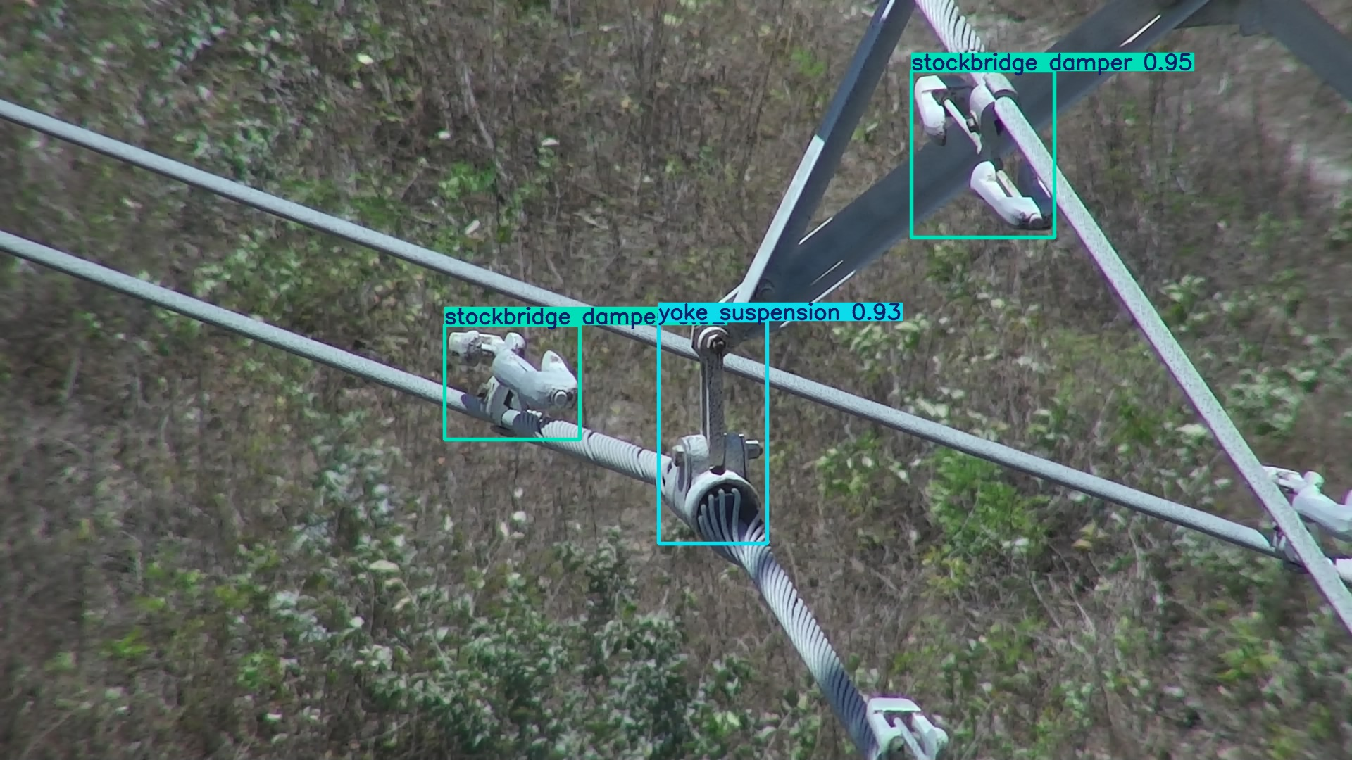
SwiftAI-Powered Damage Identification: Utilizing deep learning algorithms to automatically identify the type and severity of grid infrastructure damage while detecting hazards such as fallen trees and foreign objects within transmission corridors, generating damage distribution maps and repair work orders.
Multi-Temporal Data Comparison & Resilience Assessment: Integrating historical data with real-time damage information to evaluate grid vulnerabilities and simulate restoration sequences under different scenarios, providing data support for long-term grid planning.
 Application Scenarios & Client Value
Application Scenarios
Post-Disaster Rapid Assessment: Acquire panoramic imagery and 3D models of affected areas immediately after a disaster to support emergency command decisions.

Grid Infrastructure Damage Evaluation: Precisely identify tilted towers, broken lines, and damaged transformers, generating prioritized repair lists.

Right-of-Way Hazard Detection: Identify fallen trees, landslides, and foreign objects within transmission corridors to prevent secondary disasters. 
Visualized Restoration Progress Tracking: Real-time tracking of repair crews and materials with dynamically updated recovery plans.

Grid Resilience Planning: Analyze historical disaster data to identify grid vulnerabilities and guide differentiated infrastructure upgrades.
Client Value
Accelerates Emergency Response: Reduces damage assessment time from days to hours, capturing the critical window for power restoration.
Mitigates Repair Decision Risks: Optimizes resource allocation based on accurate data, avoiding blind operations and waste.
Enhances Grid Resilience: Systematically identifies grid vulnerabilities to reduce outage risks from extreme weather.
Safeguards Critical Loads: Prioritizes power restoration for hospitals, transportation hubs, and communication facilities.
Builds Digital Emergency Capabilities: Accumulates disaster data and response experience for continuous improvement in disaster prevention and mitigation.


