 AIMS
AIMS AIMS-H Long Focus
 Farsightв„ў System
 Riegl VQ-1560i
 Riegl VQ-780II
 UltraCam Eagle M3
 Y-1 VTOL UAV
 Aerial Acquisition
 UAV Acquisition
 Satellite Acquisition
 Field Acquisition
 Integrated
 LiDAR
LiDAR Orthophoto
 DEM
DEM DTM/DSM
 3D Mapping
 Topographic
 Infrared
 Feature Extraction
 BIM
BIM Transportation
 Water
Water power
power  Forestry
 Agriculture
 Mines & Quarries
 Heritage Buildings
 About feiyan
 Recognition
 Cases
Cases

search


Solution

Forest Health Monitoring
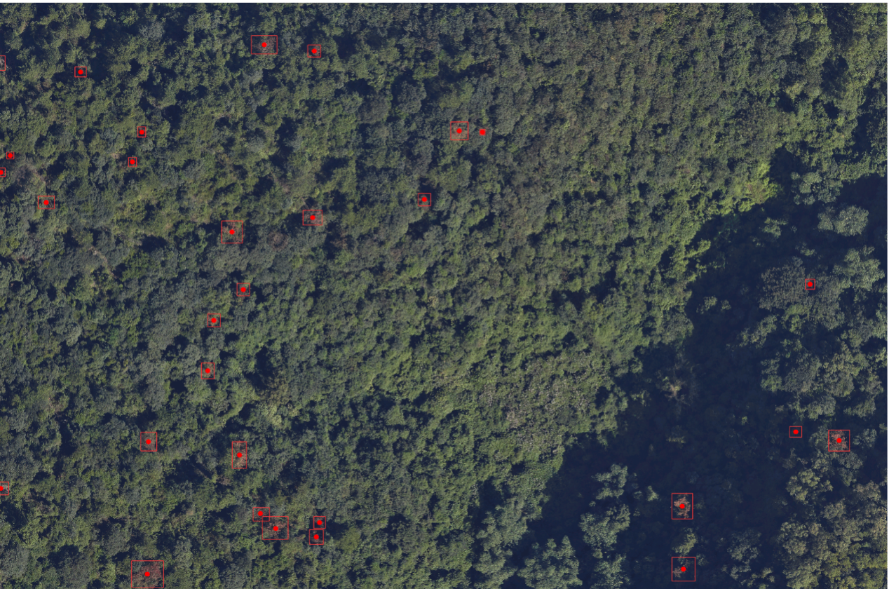
Pine Wilt Disease, caused by the pine wood nematode, is a devastating global threat to forest ecosystems, leading to rapid tree mortality and significant economic loss. Traditional monitoring methods are no longer sufficient to combat its spread effectively.
Feiyan introduces a next-generation, AI-driven Forest Health Monitoring Platform. This integrated solution leverages high-resolution aerial remote sensing, proprietary deep learning algorithms, and cloud-based analytics, transforming how forestry and environmental agencies manage forest health by enabling a shift from reactive response to proactive, data-driven stewardship.
Our Differentiated Solution Framework
Our framework is an integrated, closed-loop system that ensures precision and reliability across the entire workflow from data capture to decision support.
1. End-to-End Data Assurance System
We employ a flexible hybrid aerial survey model combining UAVs and manned aircraft to capture high-quality orthophoto imagery with a resolution better than 10cm. Data undergoes professional processing for color balancing, orthorectification, and seamless mosaicking, resulting in geometrically accurate Digital Orthophoto Maps (DOMs) that form the perfect foundation for AI analysis.
2. AI Core Powered by a Full-Scenario Sample Library
We have built an industry-leading full-scenario sample database for Pine Wilt Disease. It encompasses features from different tree species across all health stages and crucially includes confounding factors like dead tops, wind damage, other pests, and drought stress. This significantly enhances the model's generalization capability and anti-interference performance in complex real-world conditions, ensuring precise and reliable identification.
3. Highly Automated Intelligence Interpretation Pipeline
The platform features a fully automated pipeline from data processing to final output. Through intelligent tiling and batch AI inference, it rapidly locates suspected infected trees from vast imagery and automatically generates geotagged vector files of infestation distribution and visual thematic maps. Results can be directly imported into mobile GIS devices, guiding field teams for targeted verification and precise treatment, creating an efficient "detection-location-action" closed loop.
4. Turnkey Full-Cycle Service Delivery
Beyond the technology platform, we provide a comprehensive service covering mission design, compliant flight operations, image processing, AI interpretation, deliverables, and technical consulting. Clients can obtain ready-to-use "turnkey" insights for management decisions and field actions without substantial upfront investment in hardware or specialized teams, significantly lowering the barrier to adoption and total cost of ownership.
Application Scenarios & Client Value
Scenario | Core Challenge | Our Solution | Value Delivered to Client |
Regulatory Disease Census | Efficiently completing mandatory annual large-scale surveys while ensuring comprehensive, objective, and traceable results. | Rapid, wall-to-wall aerial coverage combined with automated AI interpretation and location of infected trees. | Ensures regulatory compliance, establishes an accurate spatiotemporal baseline database for analyzing spread patterns and evaluating long-term control efficacy. |
Precision Eradication Operations | Allocating limited resources precisely to the highest-priority zones during treatment seasons to maximize efficiency and impact. | AI outputs generate "Single Map of Infection Locations" and "Treatment Work Orders" to guide field crews with precision. | Shifts from "area-wide patrol" to "pinpoint eradication," significantly improving field efficiency and reducing overall costs for rapid, targeted containment. |
Protection of Key Zones | Establishing a routine monitoring mechanism for high-value areas (e.g., nature reserves, scenic spots) to enable early detection and warning. | Provides periodic (e.g., quarterly) monitoring services, functioning like a "Forest CT scan" to detect early-stage infection spots. | Enables targeted preventive measures, transforming passive response into active defense to safeguard core ecological and economic assets. |
Treatment Efficacy Assessment | Objectively quantifying the actual effectiveness of control measures to inform future strategy optimization and justify funding. | Conducts comparative monitoring before and after treatment, precisely analyzing changes in the number and distribution of infected trees. | Scientifically evaluates the ROI of control programs, providing managers with data-driven decision support to enhance the cost-effectiveness and management precision |


