AIMS
AIMS AIMS-H Long Focus
 Farsightā¢ System
 Riegl VQ-1560i
 Riegl VQ-780II
 UltraCam Eagle M3
 Y-1 VTOL UAV
 Aerial Acquisition
 UAV Acquisition
 Satellite Acquisition
 Field Acquisition
 Integrated
 LiDAR
LiDAR Orthophoto
 DEM
DEM DTM/DSM
 3D Mapping
 Topographic
 Infrared
 Feature Extraction
 BIM
BIM Transportation
 Water
Water power
power  Forestry
 Agriculture
 Mines & Quarries
 Heritage Buildings
 About feiyan
 Recognition
 Cases
Cases

search


Cases

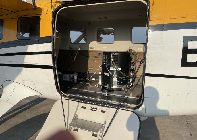
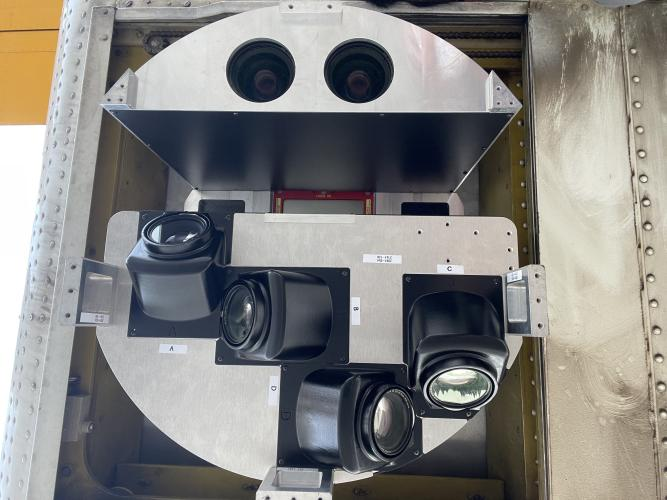
Aerial Integrated Multi-sensor
AIMS is a patented multi-sensor system integrating a nadir camera, oblique cameras, LiDAR, and a hyperspectral imager on one platform. It enables synchronous data acquisition in a single flight, delivering aligned 284MP orthoimagery, 150MP oblique imagery, LiDAR point clouds (2 million points/sec), and hyperspectral images. The
AIMS (Aerial Integrated Multi-sensor) is a patented, internationally pioneering system developed by Feiyan Remote Sensing. It represents the ultimate solution for high-efficiency, high-precision geospatial data acquisition. By integrating a nadir camera, oblique cameras, a LiDAR scanner, and a hyperspectral imager into a single platform, AIMS revolutionizes traditional surveying by enabling the synchronous capture of multi-source data in a single flight. This āone-flight, all-dataā approach delivers perfectly aligned datasetsāincluding 284-megapixel orthoimagery, 150-megapixel oblique imagery, dense LiDAR point clouds at 2 million points per second, and hyperspectral imagesāeliminating the need for multiple missions and ensuring unprecedented efficiency and data consistency for global surveying and mapping professionals.

Core Advantages
Internationally Pioneered Ā· Multi-Source Synchronizationļ¼The world's first integrated multi-source data acquisition technology, synchronously capturing hyperspectral, true-color, LiDAR point cloud, and 3D tilted data in one flight, avoiding repeated operations and significantly improving data acquisition efficiency and consistency.
Ultra-High Precision Ā· Outstanding Performanceļ¼Equipped with the AP60 POS system, featuring vertical error <0.02m and horizontal error <0.05m; the vertical accuracy of point clouds reaches a root mean square error (RMSE) of only 0.058m at 1500m flight altitude in Nanjing test area, and the aerial triangulation check point error is ā¤0.079m for 1:500 scale in Changzhou, meeting high-precision surveying and mapping standards.
High-Definition Imaging Ā· Detailed Presentationļ¼The nadir module delivers 284MP single images and the tilted module 150MP, combined with 3.76Ī¼m high-sensitivity pixels and 83dB high signal-to-noise ratio, capturing fine ground features clearly; the hyperspectral module with resolution better than 5nm accurately identifies material spectral characteristics.
Efficient Adaptation Ā· Flexible Operationļ¼Compatible with multiple flight platforms, the LiDAR module captures 2 million points per second, and the system frame rate reaches 2fps, enabling large-area coverage in a single flight; supports quick storage replacement to meet long-term continuous operation needs.
Data Fusion Ā· Value Multiplicationļ¼Multi-source data synchronization is better than 1ms, with strong consistency and correlation, which can be directly used for fusion analysis without complex registration, providing complete data support for realistic 3D modeling, ground object classification, and resource exploration.
Stable & Reliable Ā· Environmentally Adaptableļ¼Operating temperature range of -5ā~40ā and storage temperature of -10ā~55ā, adapting to different climatic conditions; modular design and multiple protection mechanisms ensure equipment stability and data security in complex operating environments.
Primary Application Fields
Digital Twin & Smart City Development: Creates high-fidelity, semantically rich 3D city models by seamlessly combining classified point clouds with textured mesh from oblique imagery, forming the essential spatiotemporal information cloud platform for urban management.
Precision Agriculture & Forestry Management : Utilizes hyperspectral data for crop health analysis and LiDAR for canopy structure and biomass estimation, enabling data-driven decisions for sustainable resource management.
Infrastructure Inspection & Corridor Mappingļ¼Ideal for efficient, comprehensive surveys of power lines, railways, highways, and pipelines. It captures everything from terrain and vegetation encroachment (LiDAR) to asset condition (imagery) in a single pass.
Large-Scale Topographic Mapping & Base Mapping : Dramatically accelerates the production of high-accuracy Digital Elevation Models (DEM), Digital Surface Models (DSM), and true orthophoto maps (DOM) for national and regional surveying projects.
Natural Resource Monitoring & Environmental Protection : Provides a comprehensive toolkit for monitoring mining activities, managing water resources, assessing ecological changes, and supporting environmental impact studies.


-
 May 10, 2021
First flight of AIMS
Recently, AIMS,which is theĀ aviation integrated multi-sensor aerial camera,independently developed byĀ Feiyan Aerial Remote SensingĀ Technology Co. , Ltd.Ā has beenĀ successfully carried out the preliminary flight . Nowadays,AIMSĀ is the only oneĀ equipment that has integrated Orthophoto true-color camera, laser radar camera, Tilt Camera, multi-spectral camera, hyperspectral camera, synthetic aperture radar camera and other common aerial sensorsĀ in China.Ā It can acquire multiple data one-time. More > -
Jul 18, 2022
AIMS - Aerial Remote Sensing Solution
The 2022 Real 3D Innovation Summit was successfully held in Guangzhou on January 12. It is guided by the Guangdong Society of Geodesy, hosted by Taibo.com, and co-organized by Feiyan Remote Sensing. It attracted more than 300 experts and industry representatives to attend. More > -
Mar 23, 2022
AIMS Preliminary Flight
Recently, AIMS, which is the aviation integrated multi-sensor aerial camera, independently developed by Feiyan Aerial Remote sensing Technology Co. , Ltd. has been successfully carried out the preliminary flight. More > -
Dec 13, 2025
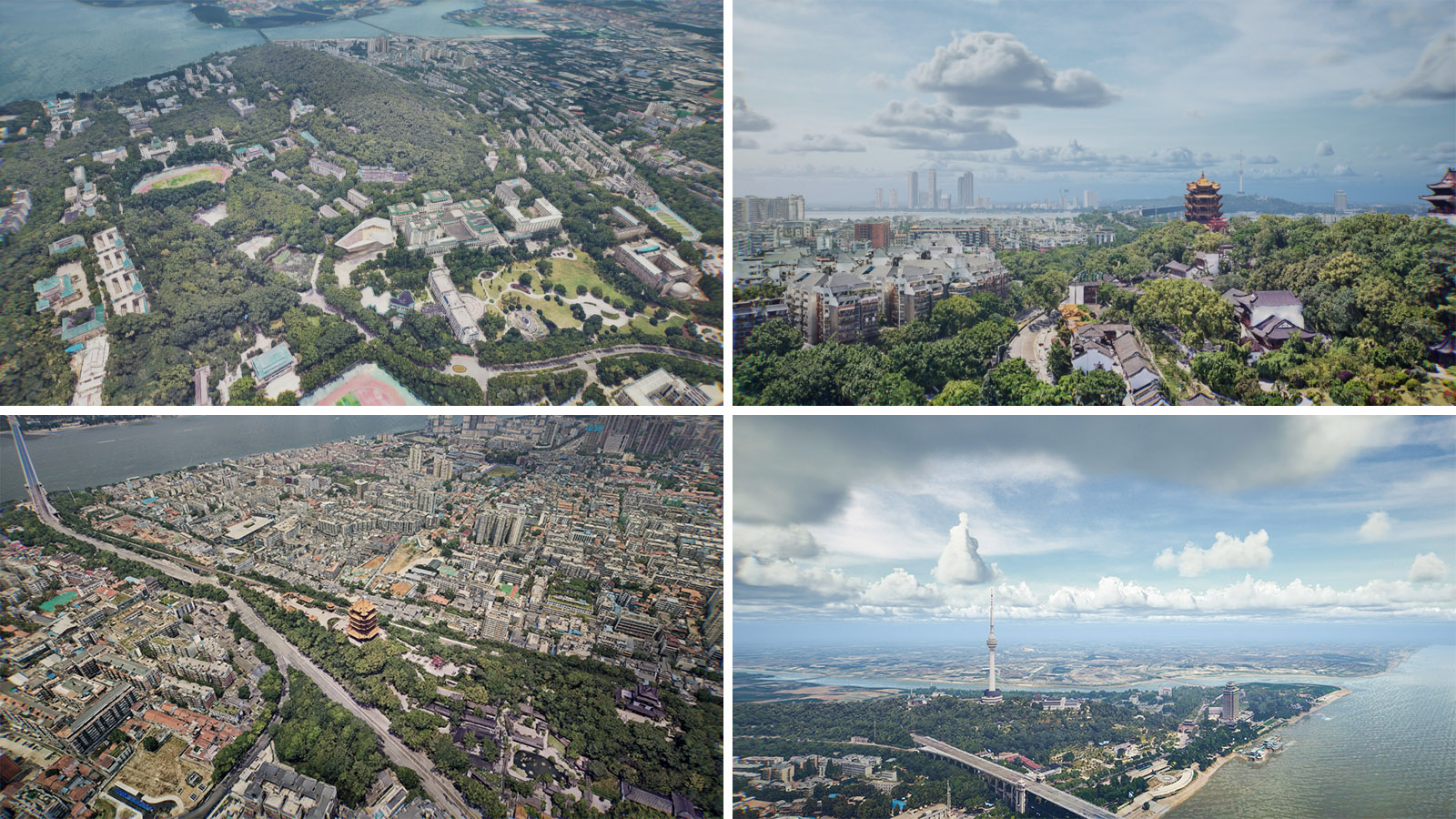
AIMS Multi-Modal Aerial Survey System Supports 3D Reality Modeling in Wuhan
Wuhan, acclaimed as China's āCapital of Remote Sensing,ā is situated at the confluence of the Yangtze and Han Rivers. The city is home to the historic poetry of the Yellow Crane Tower and the serene beauty of East Lake, while also pulsating with the momentum of modern technology. More >