AIMS
AIMS AIMS-H Long Focus
 Farsightâą System
 Riegl VQ-1560i
 Riegl VQ-780II
 UltraCam Eagle M3
 Y-1 VTOL UAV
 Aerial Acquisition
 UAV Acquisition
 Satellite Acquisition
 Field Acquisition
 Integrated
 LiDAR
LiDAR Orthophoto
 DEM
DEM DTM/DSM
 3D Mapping
 Topographic
 Infrared
 Feature Extraction
 BIM
BIM Transportation
 Water
Water power
power  Forestry
 Agriculture
 Mines & Quarries
 Heritage Buildings
 About feiyan
 Recognition
 Cases
Cases

search


Feiyan Remote Sensing won 1 Gold and 1 Silver in the 2022 CAGIS
Aug 24, 2022
Feiyan Remote Sensing won 1 Gold and 1 Silver in the 2022 CAGIS
Congrats! Two project of Feiyan Remote Sensing called âGuangxi Forest Resources Airborne Lidar Data Processingâ (âGuangxiâ) and âHefei Geographical National Conditions Monitoringâ (âHefeiâ) won the Gold Award and Silver Award respectively for national excellent project Geographic Information Industry in 2022 .
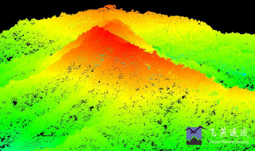
The Guangxi Project acquired airborne Lidar data of 63,000 square kilometers in Guangxi Zhuang Autonomous Region, using RIEGL VQ-1560i. The classification accuracy of vegetation points is greater than 98%. Also, the results of laser point cloud classification for forestry are formed, which is conducive to understanding the types, quantity, quality and distribution of forest, woodland and forest resources.

The DSM of Guangxi Project
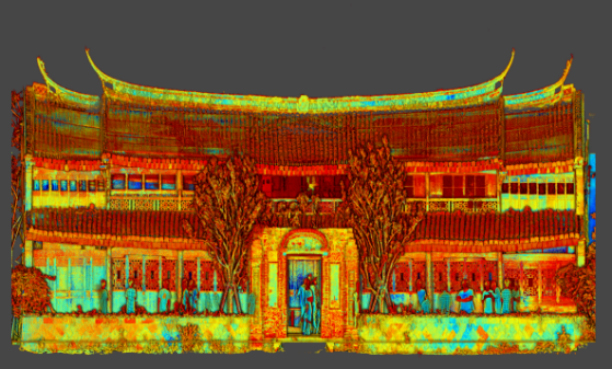
The Hefei Project completed about 1,500 square kilometers of aerial photography, and made 0.1 m orthophoto in 2021. In particular, for about 450 square kilometers of the Chaohu secondary protection zone, we have made 0.1m oblique photography and a real 3D model. These results showed the changes of various natural resources during the lush season vividly. Furthermore,it can monitor the planting status of cultivated land, ecological protection and restoration, and provide support for urban planning and construction, natural resource survey and monitoring.

The 3D Model of Hefei Project


-
 Jun 17, 2022
Satellite Technologies For Plant Nutrient Deficiency Identification And Treatment
Satellite Technologies For Plant Nutrient Deficiency Identification And Treatment More > -
Jun 22, 2022
Historical Building Surveying and Mapping
China will further step up efforts to safeguard and transmit historical and cultural heritage as part of ongoing urban and rural development strategies. More > -
Mar 22, 2022
Utility of oblique aerial photography
With the rapid development of China's social economy, the value of real estate is increasing accordingly, which makes the country pay more and more attention to real estate surveying and mapping, and the requirements are higher and higher. More > -
Mar 22, 2022
What is tilt photography?
Tilt photography is a new and high technology developed in recent years in the field of international Remote sensing surveying and mapping. By carrying multiple sensors on the same flight platform and collecting images from different angles such as vertical and tilt, more complete and accurate information of ground objects can be obtained. More > -
Mar 22, 2022
Feiyan Remote Sensing LiDAR aerial photography project accumulates over 100,000 square kilometers
At present, airborne LiDAR technology has made great progress and has been widely used in many fields. Following the trend of technology development, feiyan Remote sensing has long been in the forefront of the industry. More > -
Mar 22, 2022
Mount Everest Elevation Measurement in 2020
On the afternoon of April 30, the first press conference of the 2020 Mount Everest elevation measurement was held at the Everest Base Camp, and the 2020 Mount Everest elevation measurement was officially launched. More > -
Mar 22, 2022
What are the restrictions on drone aerial photography?
Compared with traditional Aerial photography, the low efficiency of UAV Aerial photography has become one of the main bottlenecks restricting its development. More > -
Mar 22, 2022
The 6th Jiangsu University Surveying and Mapping Geo-Information business plan competition achieved
The 6th Jiangsu University Surveying and Mapping Geo-Information business plan competition achieved full success last week. Feiyan Remote sensing participated in this event as one of the chief co-sponsors. The competition provides an excellent platform for our students, played a major role in cultivating talent of Surveying and Mapping Geo-Information application as well. More > -
Mar 22, 2022
7 Ways to Process LiDAR Data
LiDAR technology has given the spatial data industry some of the largest data volumes weâve ever seen. Most point clouds Iâve worked with have been tens of gigabytes in size. More >